
Feature release August 2025
This article highlights the new features and enhancements released by Qargo this month.
Week 1
Configuration: More user languages available
Cross dock: Improved visibility for loaded pallets
Cross dock: Free scan pallet to order / scan to load leg
Orders: Allow filtering on POD type
Orders: Calculating loading meters, including stackable
Week 3
Geofencing for stop management
Orders - Qi document scanning: Notes / instructions
Orders / Loads - Location filtering based on distance
Integration - Streamline driver times from Transics
Resources - Compatible resources improved selection process
Week 4
Configuration - Improved flexibility for price index fuel surcharge
Customers - Credit limit transparency
Planning - Improved map visualizations
Week 1
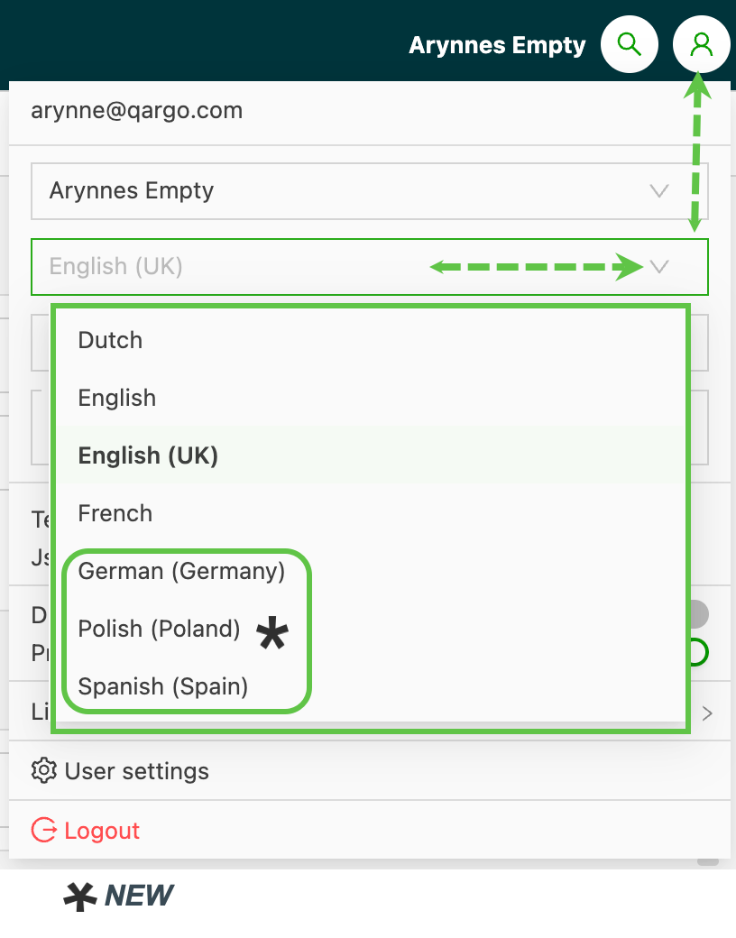
Configuration: More user languages available
Users can choose from the following language options:
- Dutch
- English
- English (UK)
- French
- German*
- Polish*
- Spanish*
Cross dock app: Improved visibility for loaded pallets
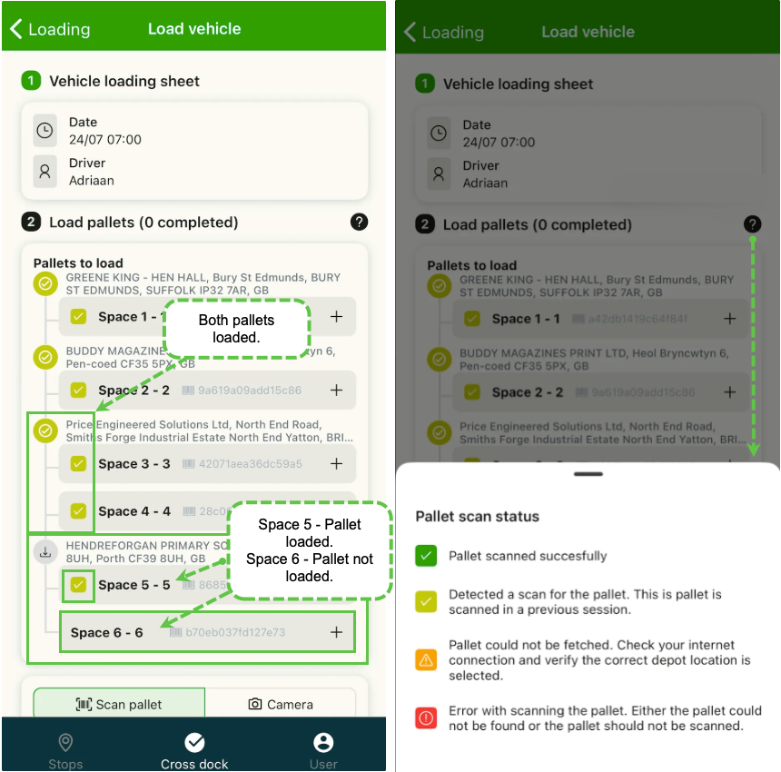
When loading freight at the cross dock, not all the required pallets may be loaded at the same time; often just one pallet goes on a truck, which returns later to load more.
The Qargo CrossDock App has been updated to improve visibility for loaded pallets. It gives clear indicators for which pallets have already been loaded, along with additional alerts that indicate potential errors.
Using color-coded indicators, users can now clearly see which pallets are loaded and which are still waiting.
Cross dock app: Free scan to assign pallets to loads
Users can now assign available pallets to an existing load by simply scanning, without needing to pre-plan every detail. This is designed to reduce friction in fast-paced loading environments while maintaining control and traceability.
Key details:
-
Enabled by default: pallets can be scanned onto loads directly from the ‘Loading’ screen in the app
-
Requires the order leg to be in ‘To plan’ status with a valid terminal leg
-
Scan the vehicle loading sheet or manually enter the load number to begin
-
Pallets not yet assigned to the load will prompt a confirmation before loading
-
Successfully scanned pallets will:
- Show a dark green check
- Be added to the load
- Update the leg with assigned load and resource details
- Once scanned, pallets are automatically route-optimized, which saves time and ensures accurate load planning.
Loading warnings
If a pallet cannot be loaded, a message explains why. Common reasons include:
- Order leg not in ‘To plan’ status
- Multiple eligible legs
- Load not found or not yet planned
- Terminal not selected
Click the link below👇 to learn more about the new cross dock scanning features.
Learn more about cross dock scanning
Orders / Loads: Allow filtering on POD type
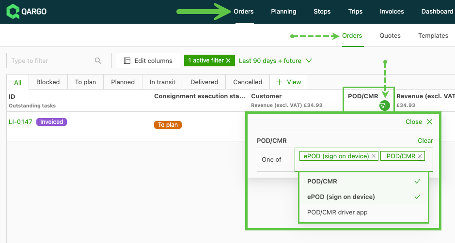
Visibility of POD documentation has been improved with enhanced filtering on this column on the Orders and Loads pages.
- From the Orders list view, filtering has been added to the POD/CMR column that allows users to filter based on the type of POD.
-
Options include:
- ePOD
- POD/CMR
- POD/CMR driver mobile app
-
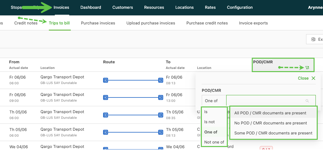
From the Loads and Loads to bill views, POD/CMR column filter options include:
- All POD / CMR documents are present
- No POD / CMR documents are present
- Some POD / CMR documents are present
-
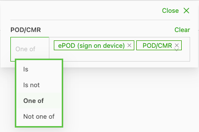
Filter options include:
- One of: Select single or multiple options from the list, indicated by a check mark. Only the selected option(s) will show.
- Is: Select a single option from the list; only the selected option will show.
- Is not: Select a single option from the list; the selected option is excluded from the results shown.
- Not one of: Select single or multiple options from the list, indicated by a check mark. The selected option(s) will be excluded from the results shown.
Orders: Create loading calculations
Freight rating often depends on how efficiently freight is loaded. Until now, users had to calculate these metrics manually, which risked errors and added time to the process.
Users can now create custom loading calculations to auto-populate values for:
- Loading meters (LM)
- Pallet spaces
These calculations are based on piece dimensions (height, length, width and weight) entered directly on the order capture page.
Why it matters
- Reduces manual entry and formula errors
- Streamlines rating workflows
- Supports stackable vs non-stackable configurations
- Enables smarter order capture for both internal users and customer portal users
Configuration is quick and easy.
Using it in orders
- When creating an order, click “Add piece dimensions” under the Freight section
- If using predefined package sizes, values may pre-fill
- LM and pallet spaces will show in green with a note: “Calculated after save”
Click the link below👇 to learn more about how to create and use these calculations.
:::
Week 3
Geofencing for stop management
Qargo now supports geofencing, which automatically detects when vehicles enter or exit defined areas around locations. This feature improves stop accuracy by autocompleting arrival and departure times based on geofence triggers. This reduces reliance on manual driver input.
Configurable at both tenant and location levels, geofencing provides:
- More reliable stop updates with precise timestamps
- Automatic stop completion (when using telematics)
- Improved ETA calculations and fewer driver/office calls
- Customizable geofence radius and deviation thresholds
Geofencing captures arrival/departure data seamlessly and highlights deviations when they occur. This gives operations teams more accurate, real-time visibility into stop performance.
Click the link below👇 to learn about geofencing in Qargo
Orders - Qi document scanning: Notes / instructions
When an order is created from an uploaded order confirmation, new key fields are scanned and helpful suggestions are offered.
- Descriptions & additional instructions: Suggestions are automatically generated based on relevant content found in the uploaded document.
- Smart data capture: The document scanner identifies numeric values, addresses, dates and times for potential use during order creation.
- Inline suggestions: These suggestions appear directly in the applicable fields for quick review and easy input.
With this update, order creation becomes faster, more accurate and less manual, taking users from document to order in just a few clicks.
Orders / Loads - Location filtering based on distance
The Coordinates filter option allows quick and easy selection of orders based on locations. Selecting this option opens a map preview where the user can manually define an area.
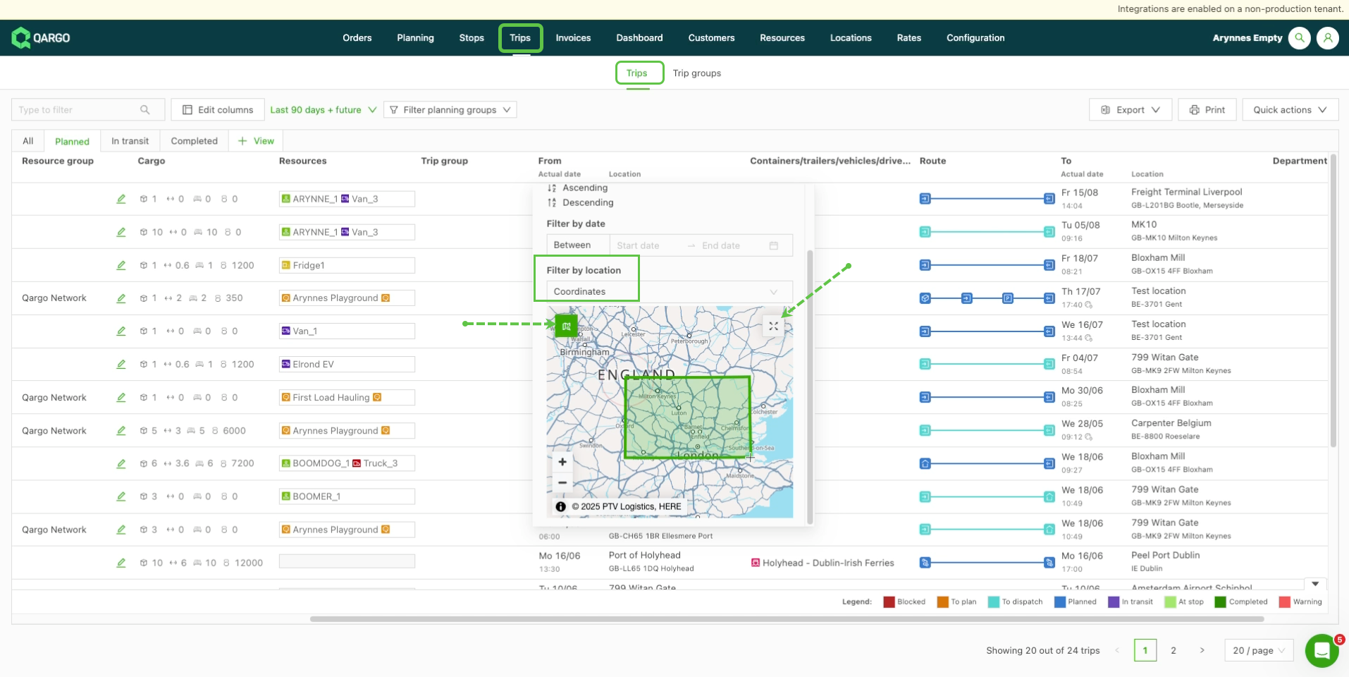
- Once the area is marked on the map, all orders with locations in the defined area are selected and displayed.
- The map can be expanded with the icon in the top right corner for a larger view. This makes it possible to move the map and zoom in as needed.
Click the link below👇 to learn more about filtering data in the order views.
Integration - Driver breaks, rest & drive time visibility in Qargo
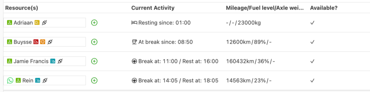
Users can now view driver activity data directly in Qargo when connected to supported FMS providers.
With this update, Qargo users integrated with Transics can now track:
- Current driving time
- Current break time
- Current rest time
- Next break due
- Next rest due
In addition, vehicle telemetry data is also available, including:
- Current mileage (default)
- Current fuel level (default)
- Axle weight (optional, requires activation)
Configuration made simple
To enable these features, add the Transics ID to the relevant driver or trailer profile in Qargo. Once saved, driver and vehicle data syncs seamlessly, provided the information is available in the FMS.
FAQ - Driver break, rest & drive time visibility
Resources - Compatible resources improved selection process
Setting up and modifying compatible resources for order capture and load cost calculations is easier.
-
Under Rates > Order input, when the option to add a ‘compatible resource’ is available, it can easily be added in the table under the configuration panel.
-
Ordered by type (vehicle, driver, container, contract carrier, intermodal connections).
-
Click into the line, or use the ‘Edit’ icon, to open the table and select the resource(s)
- Select single, multiple or all with a simple click
- Under Rates > Load cost calculations, under ‘Linked resources’, if the toggle ‘use price list for all’ is off, the resource type options will show.
- Click into the appropriate line to open the resource types
- Select single, multiple or all with a simple click.
Week 4
Configuration - Improved flexibility for price index fuel surcharge
Users can now directly configure a price index tied to the percentage of fuel within the transport charges. This ensures more accurate cost allocation and dynamic surcharge management in line with fuel price fluctuations.
-
Fuel % configuration:
- Specify the portion of total transport costs attributed to fuel (
Fuel: % of the total cost). - Allocate up to 100% of the charge as fuel cost.
- Flexibility to set any percentage (e.g., 50% of the charge = fuel cost).
- Specify the portion of total transport costs attributed to fuel (
Automated surcharge calculation:
The system dynamically calculates the surcharge using the formula:
(Index Value - Base Value) / Base Value * Fuel % = Price Index RateBenefits
- Transparent and configurable allocation of fuel costs.
- Flexibility to adjust fuel surcharge percentages per contract or service.
- Automated, accurate surcharge calculations applied directly to orders.
Customers - Credit limit transparency
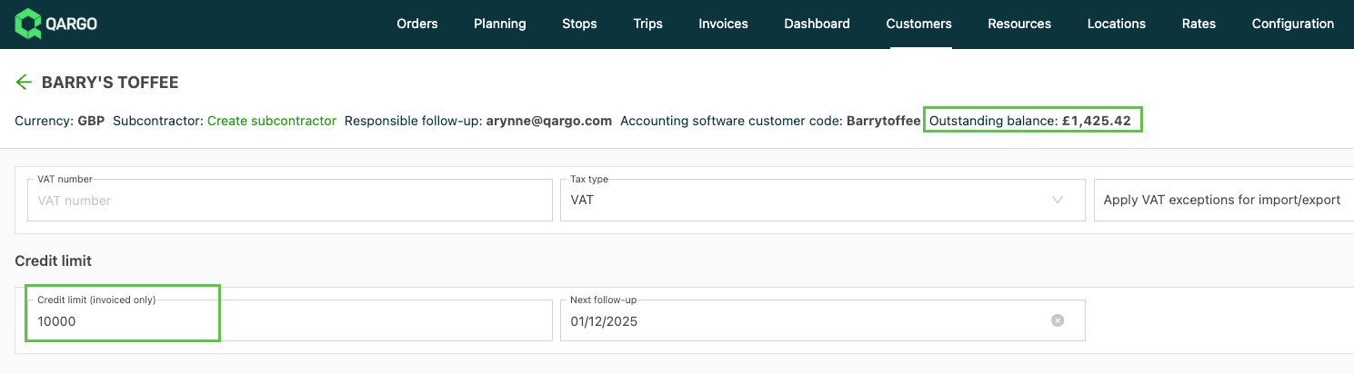
It is now possible to add a customer credit limit to customer profiles. Greater transparency on this element helps to:
- prevent overexposure to outstanding receivables
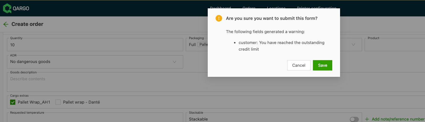
- proactively manage customer relationships when creating orders
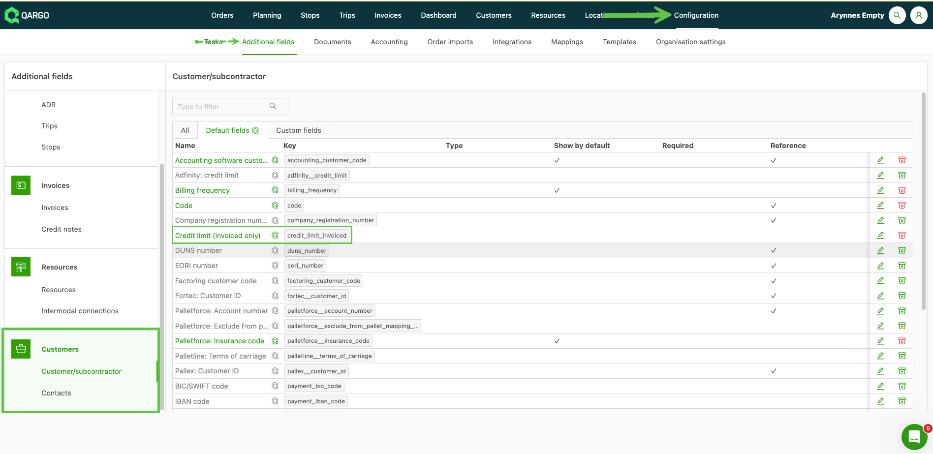
Configuration
- The additional field ‘Credit limit (invoiced only)’ must be active
Visualization
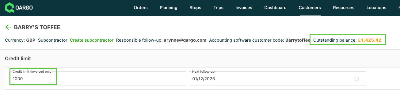
- The outstanding balance shows in the customer profile header
A balance within the credit limit shows in black.
An outstanding balance over the credit limit shows highlighted.
Over credit limit warning when adding orders
Planning – Smarter map visualization with routes & stop markers
Map visualization that makes route planning clearer, smarter and more intuitive.
With this update, users can now:
- See planned routes at a glance – Each route is displayed in a unique color for easy distinction. Turn them on or off with a single toggle in the legend.
- Understand stop details instantly – Stop markers now show sequence numbers, and if multiple stops share a marker, they’re color-coded to indicate each route.
- Customize stop marker sizes – Adjust marker sizes based on the most important metrics, such as pallet spaces, loading meters, volume or weight. Thresholds for small, medium and large markers can be configured.
- Get more meaningful data on stops – When using metrics like pallet spaces or loading meters, values are displayed directly on the stop markers for quick reference.
- Use colors more effectively – Trucks and trailers assigned to a load now appear in the same color as their planned route. Unplanned stops remain black for instant visibility.
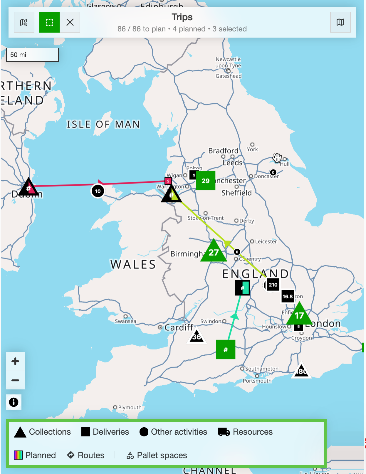
These changes provide better visibility, reduce clutter and make it much easier to manage both planned and unplanned loads.
Click the link below👇 for more information on the new map visualization.
:::